
You can't see any of this from Apache Trail; it's hidden by paloverdes.
The area around this entrance was burned in a wildfire 5 or 6 years ago. I almost got trapped on the wrong side of the fire when Apache Trail was closed (I was 10 miles from home but would have had to drive about 90 miles to get there).

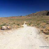
Looking back towards the entrance. The landscape seems barren out here.
The area that was burned still looks very different from the rest of the desert. It looks like something is missing. There are very few chollas or prickly pears or paloverdes or creosote or catclaw.

It looks very desolate out here. Maybe part of the reason why is because I was taking pictures in the early afternoon. The desert always looks severe then.
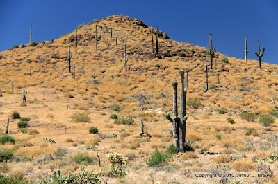
Notice the gray saguaros. That's because they were burned. The only green is near the top.
I was hoping that by using the Cottonwood entrance, I could get to the part of the Goldfield Mountains I've been exploring lately more easily. It didn't work out that way, though. I got to a spot in the road that I didn't think I would be able to drive back up if I had to come back this way. I've come across 3 places like that this weekend. I wish I could come across them in the other direction. As it is, I turn around without really knowing. I can't try it because if I drive down and can't drive back up, I'm stuck out in the middle of nowhere and there ain't nobody else out there. I've driven up some hairy looking slopes and when I drive back down them on the way out, they look pretty scary. I've also been unable to drive up slopes that look pretty mild, so if it looks at all questionable, I don't chance going down the slope.

Ah, something for scale.

Somebody dug a hole in the middle of the road.

It doesn't look steep from this angle, but the tire marks on the rocks are a warning.

I almost forgot to take a picture of Four Peaks.

Got lots of pictures of the Supes, though.
Click below to see all of the pictures.
 |
| 2010_06_20 |


No comments:
Post a Comment