
I think I got only one picture of Lone Mountain.
I headed for a spot I'd been to only once before, before I had a way to geotag pictures. I was going along the base of Pass Mountain, which means there were a lot of ups and downs. Normally when I'm just wandering around out there, I'll walk along ridges or washes so I don't have to work so hard. I'm a lazy person at heart. This time, though, I wanted to get to a specific area, so I went as straight as possible. I tried to move quickly, stopping only to take pictures, because I got kind of a late start. Up, down, up, down, up, ....

I'm going in that direction.

The view in the other direction.
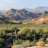
I took pictures mostly in just two directions, because of the angle of the sun and because of the view in those directions. I didn't go quite as far as I wanted to, but it was getting late and would soon be too dark for pictures.

Nice scenery in that direction.

Well, kinda boring in that direction.

Here you can see the wavy terrain.
I took a slightly different, parallel route on the way back. It sure made a huge difference in how much up and down there was. It was almost flat compared to the way out there.

This saguaro is REALLY big. I couldn't find anybody to stand next to it for scale, though. Thank goodness.
The sun was behind mountains for several minutes before I got back to the truck. The low spots in the terrain were filling with cool air. It felt great. By the time I drove out, it was down to 76. It was almost 90 when I got back to town, though. Click below to see all of the pictures.
 |
| BC_2010_06_02 |


No comments:
Post a Comment