
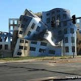
I even took in a few sights around town. This is the Lou Ruvo Center for Brain Health. I couldn't find a (free) place to park, so this is through the windshield. There was very little traffic around, so I was able to sit at the light until I got a picture.
I wanted to get to a higher altitude than I had last year (so it would be cooler), so I headed for Mt Charleston on the first day out. My original plan was to hike to the top of Cathedral Rock. Halfway up the mountain, I realized that I had forgotten to get water on the way out of town. I didn't have enough with me to climb 1000 feet. I was only mildly disappointed because I didn't relish the thought of climbing 1000 feet starting at about 8000 feet.

Cathedral Rock is much larger than it looks in this picture.
I checked a map at the visitor center and picked a trail that was just 1.8 miles long (twice that out and back) and climbed only 300 feet or so. It started out at about 7000 feet and the trailhead was just a few hundred feet from where I was standing. The temperature was about 73 when I started the hike.

The beginning of the Fletcher Canyon trail.
Something unusual (to me) about the Fletcher Canyon trail is that the ground was very bright. I'm used to clouds being washed out in pictures, but not the ground. I didn't realize what was happening until it was too late to do anything about it.

There is nice scenery all around on the trail.

There are Ponderosa pines up here.

The trail wasn't steep and with all the trees, I was able to get out of the sun now and then (I also forgot sunscreen). The trail followed a wash and before too long I came across water flowing in it. The water was there off and on as it went below ground and came back up.

A stream of crystal clear water.
The trail eventually entered a narrow canyon. I think all my GPS toys quit working there. I think that might also be where the regular trail ends. According to other hikers up there, you can continue for miles if you want to, but you will eventually be pushing through lots of brush. I never got to the pushing through brush part. I continued up the canyon until I got to a spot where I would have to make a short climb up slippery polished rock. Time to turn around.

The beginning of the narrow canyon.

Narrow canyon.

I turned around at this waterfall.

Above the waterfall, the canyon split. This is the left fork.

This is the right fork.
On the way up the trail, I made a point of taking pictures only in the direction I was going so I would have different looking pictures on the way down. Some places look completely different from the other direction.

I think an avalanche during the winter must have knocked these trees down.
It was a very pleasant hike. Afterward, I drove around on the mountain some and found a couple of spots with good views.

A scenic view.
There were many times on this trip that I wanted to pull off the road to get some pictures. I was driving our minivan, though. Low clearance. I was afraid I'd tear it up pulling off the road just anywhere, so I missed getting pictures of lots of stuff.

I was almost to the bottom of the valley before I came to a place to pull over and get pictures of this and Joshua trees.

Joshua trees.

You have to see this in person to really appreciate it.
Click below to see all of the pictures.
 |
| 2010_06_25 |


No comments:
Post a Comment