Sunday, February 28, 2010
Video of the stream
After having lived in Arizona for several years, I can't help doing this. It seems so unusual to see flowing water, I made a video of it. This is a stream I crossed on my way to White Canyon Wilderness.
Battle Axe Road
I was looking at my EveryTrail profile the other day and discovered that I am an EveryTrail guru for the White Canyon Wilderness area. That distinction must have been bestowed upon me because I have some EveryTrail hikes that are close to there. It couldn't have been because I have hikes in there because I didn't even know where it was. I found a Bureau of Land Management website for the area. It has a description and directions for getting there, but no map. There is also a description on the Arizona Republic website, but no map. EveryTrail has a map but it can't be correct. Their map includes Superior and I doubt it goes that far north. I'd really like to see a map. I may have to create it. Or maybe I can get a map from the BLM.
Anyway, I left the house kind of late yesterday. I thought that since it was late and since it had been overcast all day, maybe there wouldn't be many people going to the Renaissance Fair to the east of Gold Canyon. I might be able to get to Superior without too much trouble, and then to White Canyon. The only trouble I had was finding Battle Axe Road. I drove by it a couple of times and glanced at the sign there and thought it said "PRIVATE ROAD", but actually it said "PRIMITIVE ROAD". I finally figured that out and headed down the road. It was in very good shape for a primitive road until I got a little ways past the right turn at the corral. High clearance became necessary and 4wd or locking rear axle highly desirable. Even then, much of the "road" was nice and smooth as it followed a wash. I soon got to places that would have had me stuck if I couldn't have locked the axle. I think the road used to follow the wash through an area that had been washed out (ha ha), leaving nothing but large boulders in the path. Since then, it looks like people have created a route around the washed-out part (still in the bed of the wash). I had to lock the axle to get on and off the alternate route, in both directions. If I wasn't so lazy, I could have made that easier by moving some small boulders to the side. Maybe next time I'm out there. Or maybe they'll get washed away with today's rain. Anyway, that's enough of this wash stuff.

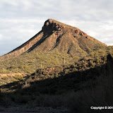
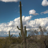
Battle Axe Road heads for Copper Butte. This is Copper Butte from the side; didn't want a picture of it shooting into the sun.
I drove along the road until I got to a fence. There is a gate, but I turned around there because it was getting late and the road was downhill and steep on the other side. I didn't want to be stuck down there after sunset.

Cottonwoods along the way.

Now that's a spring. Wonder what it looks like in July.

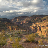
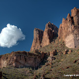
Impressive cliffs all around.

That cliff is pictured in a lot of descriptions of this area.
The area is beautiful. I didn't get to see much of it, though, and I didn't get any good pictures. I will definitely be going back. I would be there now if it wasn't raining. Click here to see the EveryTrail map. Click below to see all of the pictures.
 |
| WC_2010_02_27 |
Monday, February 22, 2010
Another rainy day
It rained off and on all day Sunday. When it wasn't raining, there were breaks in the clouds and sometimes there was a little sunshine. It was pretty weather. I drove out to the Lost Goldmine / Hieroglyphic Canyon trail head and wandered a short distance along the trail taking pictures. There were a lot of people on the trail. Some were wearing ponchos. I don't know why some of the others weren't soaking wet. It wasn't raining while I was there, but it had been recently. The trail was very muddy in spots.

The Flatiron.

Clouds on a mountain far to the east.
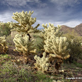
I got one picture that I really like. It's a pseudo-HDRI, but that isn't what makes it look like it does. After a rain shower, teddy bear cholla seems to glow. I don't know if it's from sunshine on them with dark clouds around them, or because the rain has washed dust off the spines, or what it is. I was walking along the trail and this cholla grabbed my attention (instead of my skin). For once, I think the picture gives an idea of what it really looked like.

"Glowing" cholla.
I took pictures of several more cholla out there, but the lighting had changed. They weren't glowing any more.

Standard cholla.
I wasn't out there long enough to catch any great cloud pictures, though I got a couple I like. Click below to see all of the pictures.
 |
| 2010_02_21 |
Sunday, February 21, 2010
Rainy day drive
It's been raining so much lately, it doesn't seem unusual any more. While running an errand Saturday morning, I saw that there were clouds covering the tops of the Superstition Mountains. It was raining now and then so I wasn't going for a hike. I decided to drive around and see if I could get some pictures with interesting clouds.

The clouds here were moving too fast to make an HDRI.
I was thinking that since it was such gloomy weather, maybe there wouldn't be any crowds at the Renaissance Fair and I might be able to drive out to Superior. As I headed east, though, I kept thinking about how the eastbound highway would probably be closed down to one lane and traffic would be slow even if there wasn't much of it. Instead of Superior, I took the Idaho exit and headed for Apache Trail.
Along the way I drove down FR80. The road goes to SRP employee housing in the Salt River canyon. There must be something else down there, but I don't know what. For some reason they don't want people wandering down there.

KEY POUT.
I stopped at the scenic walk at the top of Fish Creek Hill, too. It was really cloudy while I was there, so those pictures turned out kind of boring. There was a woman selling Indian jewelry near the start of the trail. I was going to buy some on my way back to the truck but she was gone by then. I guess it was getting late.

Agave leaves holding rainwater.
Late or not, there seemed to be a lot of traffic going up and down the Fish Creek Hill road. It's a narrow (wide enough for one vehicle much of the way) with a rock wall on one side and an almost vertical drop on the other. There's a guard rail in places, but it's the flimsiest guardrail I've ever seen; I think it would have trouble stopping a fast bicycle. There's a place where the guardrail has been knocked out and somebody spray painted on what's left, "Wish you were here, Dave. We miss you, Bro". I don't know if it's for real or a joke. There are certainly plenty of pieces of vehicles scattered down the steep sides. Anyway, I decided to drive on down to Fish Creek. I only encountered one vehicle on the way down, and none on the way back up later.

Ever hear the expression, "That's water under the bridge"? Here's a picture of it.
By the time I got back to the scenic walk, the sun was peeking out now and then. I got a few pictures that I like. It's a very pretty area, but most of the pictures I've taken of it don't do a very good job of showing what's there. The splotches of sunlight on this day added some dimensionality to the pictures.

I like what the splotches of sunlight did.
When I was almost back to the paved part of the road, I spotted something I've been meaning to get a picture of for several years. It's a rock that is shaped like a frog.

Frog Rock.
Click below to see all of the pictures.
 |
| 2010_02_20 |
Thursday, February 18, 2010
A short hike to a nice view
I left the house Sunday afternoon thinking that I needed to get out of the house for a little while. After all, it was a beautiful day. My legs were tired from Saturday's hike, so I thought I would probably just drive around for a while. I decided to make another attempt at getting to Tortilla Flat. It was later in the day and traffic didn't seem as slow, though there were an awful lot of cars on the road. I made it to Tortilla Flat and slowed down enough there that no tourists had to dive out of the way to keep from being run over. There was still some water flowing over the road, but it was open. The asphalt that had just recently been repaired was all torn up again; it's a very rough crossing again.
Now that I had seen the creek, I was thinking about stopping somewhere and wandering around a little. I thought of several places I would like to see again but didn't think I had enough light or energy to go to those places. I drove along trying to think of places out there that I've wanted to explore and wondering if the guy in front of me was ever going to shift beyond second gear and get moving (sometimes I'm a little impatient) when I remembered a very old section of road near there that was no longer used (much). I drove too far on that stretch of old road once and had to back up for about .2 miles on twisty roller coaster road. I had to lower the tailgate so I could see the road whenever I topped a rise. Anyway, I decided to go down that road again, but not the part where I had to back up to get out.
After going about a quarter of a mile I got to a wide spot where I could park. I got out to listen to the quiet, but was still too close to Apache Trail and there were still lots of people out enjoying the sunny, warm weather. I got my camera and backpack and started to wander around a little. I looked up at a ridge to the southwest and wondered what was on the other side. I thought that maybe I would hike up there some day and see, but for now I would just wander in that direction a little.
So I wandered along, spotting rocks or cacti that needed closer inspection, all the while being drawn closer to the ridge. It didn't look very steep. My concept of steep has changed considerably in the past few years. Steep used to be anything that a car in neutral would roll down. Now, steep is when you knock a rock loose and it tumbles at least 8 feet before stopping, and round rocks don't count. Anyway, I decided what the heck, I'm already here and the curiosity is driving me nuts, I'm going up. It was steep enough that I had to stop several times to take pictures.
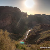
When I got to the top, I realized that I had discovered a cool place to go that hardly anybody else ever visited. The view was very nice. There was a creek below but I can't find its name on a map. It joins with other creeks and eventually crosses the road at Tortilla Flat. There was a decent amount of water flowing through it; the sound of rushing water carried up to the ridge. I could see a little bit of Canyon Lake, and the campground across the road from Tortilla Flat. Mostly what I saw was beautiful, rugged Arizona mountains.

First sighting of the creek below.

Canyon Lake in the distance.

The view to the north. I'm pretty sure I've walked along the base of that mesa in front of Four Peaks a few times.

I think I'm going to have to try to get up there some day.
I took a lot of pictures while I was up there. None convey how pretty it is. I guess if I was a real photographer, I would keep going up there until I found the right light to get the pictures I wanted. I'm sure I will be going up there again to enjoy the view.
I saw something strange out there, on the way back down. Some agaves didn't look quite right. I took a closer look and saw that something had been eating the edges of the leaves, in between the thorns. What ever did it was long gone.

Something ate between the thorns of agave leaves.
Click below to see all 45 pictures.
 |
| 2010_02_14 |
Sunday, February 14, 2010
A climb to a view
When I left the house on Saturday, I was planning to go to Tortilla Flat to see if it was possible to drive across the creek yet. It was a sunny, warm day, so I knew the traffic going out to the lake would be bad. Still, I couldn't stand being behind people puttering along at 30 to 35 mph and pulled off before I even got to the twisty part of the road.
There's a small mountain near one of the entrances to Bulldog Canyon OHV area that has an impressive looking cliff facing Apache Trail. I've been to the top of it before. The back side has a gradual slope that is easy to climb. I decided to go up there again. I took a different route this time that looked like it might be shorter. It looked like it could also be a dead end, but that didn't matter.

I decided to go to the top of those cliffs on the left.

The last time I was up there, I started climbing a long way towards the back. This time I went up a canyon nearer the front.
The desert is gearing up for spring. There are plants popping up everywhere. We might have a lot of flowers soon.
I took a lot of pictures, and put a lot of them on the web album. Maybe they'll eventually be in some cool street views.

Saguaro Lake is in that direction, but I couldn't see it.

The Superstition Mountains

I really miss the Massacre Grounds trail. I need to figure out how to get to it since the road I used to use has been closed.

Find the truck! This time, it isn't the only vehicle in the picture.
This isn't a place to hike if you want to get away from noise. It's too close to Apache Trail. Since it was such a nice day, there was quite a bit of traffic. A lot of that traffic was the noisy kind; old guys on Harleys and young guys in pickups.

This group would no doubt be proud of the racket they made.
Click here to see this hike on EveryTrail. Click below to see all of the pictures.
 |
| BC_2010_02_13 |
Monday, February 08, 2010
More storm damage, etc.
We had quite a bit of rain Saturday night, maybe a quarter of an inch. The clouds were clearing away Sunday morning and it was a beautiful day. I drove out Apache trail a little ways to see what I could see.

A view of the Superstition Mountains.

Apache Trail meanders towards Canyon Lake.
After getting a few pictures of clouds, I went down into a small canyon to check out a wreck. It looked pretty recent. Somebody had salvaged a lot of the parts.

Not much left of this vehicle. I couldn't tell for sure where it left the road. Recent rains have erased a lot of evidence.
After lunch, I headed out to Bulldog Canyon. I wanted to see if I could find a lot more toppled saguaros out there. On the way I spotted some wild horses next to the road. I stopped to get a few pictures.

Wild horses in Bulldog Canyon OHV area. The fence is to keep knuckleheads in 4WD vehicles from driving where they shouldn't, not to keep the horses in.
I wandered around for an hour or so looking for fallen saguaros. I found about 10 that I hadn't seen the last time I was out there. They seem to be concentrated in a fairly small area. I could walk a while without seeing any when I left that area, but I could usually see another one when I was standing by one in the area where they had fallen. Maybe there was a strong downburst there, or maybe the soil is really loose there (though roots had broken off of all the saguaros that fell). I took pictures of a few things besides fallen saguaros.

A stick.
All of the fallen saguaros had fallen pointing in a generally northerly direction. Seems like I remember the wind being out of the south on the day it was blowing hard.

This is a large one.

I thought a stereo picture looking up at a saguaro might look really cool. I guess it's only mildly interesting, though.
I think the album maps shows that I may have just gone around the edges of the area of fallen saguaros. While I was out there, I thought I had covered a narrower area than I really did. I'll have to go look around some more.
 |
| 2010_02_07 |
Tuesday, February 02, 2010
A short hike along the Lost Goldmine trail
Sunday was another pretty day; just a few puffy clouds on the horizon. I went out to Peralta road again. I was thinking I'd better go out there while I can. The Arizona Renaissance Festival starts this weekend, which means that going east on 60 out of Phoenix won't be easy for a few weeks. I was halfway planning to walk the length of the Lost Goldmine trail. I've been on it before, though. I was open to distractions.

The trailhead is just before the Peralta Canyon trailhead.

The mountains look different from over here.

Saguaro with a whole lotta arms.
The trail goes along the fence at the southern border of the Superstition Wilderness area. At one point when I had stopped to take some pictures, three hikers came from the other direction and started talking to me. We talked about various trails in the Superstition Mountains. As we were talking, I noticed a "gate" in the fence, and a faint tail on the other side. No, I couldn't resist.

A gate in the fence, sort of.
I could follow the trail for about 30 yards before it faded away. I saw pieces of clay pigeons and an old Penzoil bottle. I thought the trail might pick up again, so I wandered around where I thought it should go. I never saw any sign of a trail out there again. I never saw any more indications that other people had been out there (though I'm sure they had been). It was nice. There was a small hill in front of me, so naturally I climbed it. I took pictures of the hill, but you can't distinguish it from the background. It was hard to do that even when standing there. I stayed on top of the hill for a few minutes taking pictures and enjoying the view. Once, I looked back at the trail and there were four people standing there. It was kind of far away, so I couldn't tell what they were doing. I zoomed in all the way with the camera and it looked like they were just standing there looking at the mountains. I took a few pictures of them, thinking that I might be able to tell what they were doing when I looked at them at 100% on the PC monitor. The people stayed there for a really long time but finally wandered off. When I looked at the pictures later, it looked like one of the guys was pointing right at me. I guess my white T-shirt stood out.

If I had known they were looking at me, I would have waved.

A view from the hill.
When I got back to the trail, I decided to head home. I was glad I did by the time I got back to the truck. I was worn out. Hiking once a week doesn't cut it. The days are getting longer, though. Click below to see all of the pictures.
 |
| 2010_01_31 |
Monday, February 01, 2010
Fallen Giants
We had some stormy weather a couple of weeks ago. It involved a lot of rain (up to 4 inches in some places) and a lot of wind. It blew 40 mph or harder all day one day. A lot of trees along a major road near our house blew over. I didn't think about all of this having an effect on the desert, though.
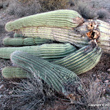
Last Friday I went for a drive through part of Bulldog Canyon. I was going along the road trying to decide where to stop and what to do when I spotted a saguaro that had just fallen over. I got out to get a closer look and take some pictures, then got back in the truck. It wasn't long before I saw another fallen saguaro. While I was looking at it, I spotted another.

The first fallen saguaro that I found.

Domino saguaros, one fell on top of another one.

Almost took out a cholla.

A paloverde blew over, too.
As I was leaving Bulldog Canyon, the moon came up. I took a LOT of pictures of it. I got the tripod out and took exposure bracketed shots to make HDRIs. I haven't found the right Photomatix settings to get the HDRIs come out, though. The moon always looks overexposed.

A non-HDRI of the moonrise.
Some day when I'm feeling ambitious I'll see if I can figure out those moonrise HDRIs. In the mean time, here are all of Friday's pictures.
 |
| BC_2010_01_29 |
Subscribe to:
Posts (Atom)


