Wednesday, June 30, 2010

Pupfish

After a refreshing day in the mountains, I decided to head in the direction of Death Valley. While looking at Google Earth, I saw something called Ash Meadows National Wildlife Refuge. It looked like it wouldn't take too long to get there. On Google Earth, it looked pretty darn boring. It was close, though, and I didn't think it would really be boring, and if it was I could just go someplace else. I didn't look up any information about it so I had no idea what I was going to see.

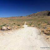
I got distracted before I got out of sight of Las Vegas. I could tell that Red Rock Canyon was to my right. Then I spotted some trails going up into some hills by the road. I thought I might be able to get some good views of Red Rock Canyon from up there, so off I went.


What would I see if I followed those trails?

As it turned out, I couldn't see much of Red Rock Canyon. The views weren't that spectacular. If I hadn't gone, though, it would have bugged me until I went back. I found out the trails are used mostly by people riding mountain bikes. I saw several out there.


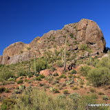
Part of Red Rock Canyon in the distance.

I used my GPS datalogger on that hike. When I got back in the van, I thought that I remembered forgetting to erase the data from the previous day's hike, so I didn't turn it back on the rest of the day. Silly me. I'll never figure out where I was when I took some of the pictures I took that day. I think I made pretty good guesses on a lot of them, though.

Again, there were a lot of things that I wanted pictures of, but couldn't pull off the road in the van. Traffic was just a little too heavy to stop in the middle of the road, too. I did pull off the road a few times. A guy in a red car and I played leapfrog for a while, stopping to take pictures.


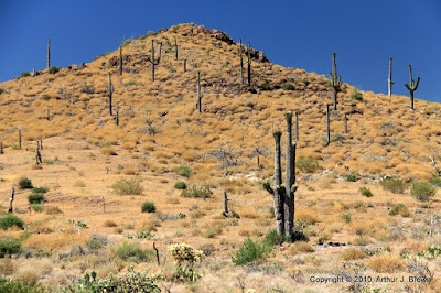
I think the Nevada desert is very pretty.


Las Vegas is back that way somewhere.


I'll have to go back and get geotagged pictures. I don't remember if this was before or after I went through Pahrump. I didn't take any pictures in Pahrump, so I can't use that to separate them.

I finally got out to the refuge. It's all dirt roads out there. They are well-maintained and smooth, but dusty. I knew Suzanne wasn't going to like the coating of dust I was going to pick up that day.


I wish I knew the name of this mountain.


This light-colored ground is *extremely* bright.

I had no idea what to expect in the refuge, so I was pleasantly surprised by just about everything. I suppose a lot of money and effort has gone towards habitat restoration out there. It looks like they are just recently getting around to making accommodations for visitors.


There are very nice boardwalks through some areas.


I was surprised to see so much water flowing. Most springs I've come across in the desert have barely a trickle of water.

I didn't expect to be lucky enough to see the rare Desert Pupfish, but they were all over the place. Well, all the places that were under water, that is. It looked like the males were spending all day chasing each other off from their territory.


I took a lot of pictures of Pupfish, hoping some would turn out. It's hard to get good pictures through water, though.

I made some short videos of the Pupfish, too. Here's the best one, except for the noise. I think it's the image stabilization. I forgot to turn it off.


I went to Devils Hole next. It's a large hole in the ground on the side of a hill. It's fenced off to keep knuckleheads out. The water is geothermally heated to about 92F.


Devils Hole. There's a lot of equipment down there for studying the fish. I didn't see any of the fish in here; too far away.


This is the deep end of Devils Hole. Depending on what you read, it's from 300 to 500 feet deep.

The next stop was Crystal Reservoir. It's a large body of water that must be filled by the springs. I don't know what kind of fish, if any, are in there. I didn't see any. After walking around in the heat for a few hours, the water looked very inviting. I didn't have a swim suit but I had seen only 4 other people out here, and they were gone now. I could go skinny dipping if I wanted to. The trouble with that is that I would probably get a bad burn on areas of my body that had never seen the sun. I decided to see what the water felt like before I got in. I couldn't get to it, though. Other people had been swimming and had left 6 inch deep footprints in the soft banks. The mud stuck. I got some on my fingers and it stayed there until I got back to Vegas. It looked like the bottom had a very gradual slope; I didn't know if I would ever get to water deep enough to float. Then there were all the things that could poke a hole in my feet. I chickened out.


It sure does look inviting.


But there's lots of stuff to poke your feet.

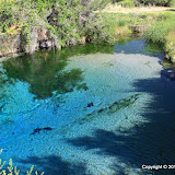
The last place I visited was Crystal Spring. There's a boardwalk that follows a stream to the spring that feeds it. I got a picture of a hawk there. Saw lots of other critters but they wouldn't pose for me.

Crystal Spring.

Click below to see all of the pictures. There's a lot of them.

2010_06_26

Tuesday, June 29, 2010

Return to Las Vegas

Suzanne had a nursing conference in Las Vegas again this June. I tagged along to explore the desert around Las Vegas some more. I enjoyed the trip much more this year. First of all, we did NOT stay at a hotel that had valet parking only. It did charge outrageous fees for internet usage, but I found unsecured wifi that worked just fine. Those two things made a huge difference. Also, I couldn't hear our neighbors from our room. Well, I did hear some kids cutting up now and then, but no drunks being a-holes at 2 a.m. Kids are OK.


I even took in a few sights around town. This is the Lou Ruvo Center for Brain Health. I couldn't find a (free) place to park, so this is through the windshield. There was very little traffic around, so I was able to sit at the light until I got a picture.

I wanted to get to a higher altitude than I had last year (so it would be cooler), so I headed for Mt Charleston on the first day out. My original plan was to hike to the top of Cathedral Rock. Halfway up the mountain, I realized that I had forgotten to get water on the way out of town. I didn't have enough with me to climb 1000 feet. I was only mildly disappointed because I didn't relish the thought of climbing 1000 feet starting at about 8000 feet.


Cathedral Rock is much larger than it looks in this picture.

I checked a map at the visitor center and picked a trail that was just 1.8 miles long (twice that out and back) and climbed only 300 feet or so. It started out at about 7000 feet and the trailhead was just a few hundred feet from where I was standing. The temperature was about 73 when I started the hike.


The beginning of the Fletcher Canyon trail.

Something unusual (to me) about the Fletcher Canyon trail is that the ground was very bright. I'm used to clouds being washed out in pictures, but not the ground. I didn't realize what was happening until it was too late to do anything about it.


There is nice scenery all around on the trail.


There are Ponderosa pines up here.


The trail wasn't steep and with all the trees, I was able to get out of the sun now and then (I also forgot sunscreen). The trail followed a wash and before too long I came across water flowing in it. The water was there off and on as it went below ground and came back up.


A stream of crystal clear water.

The trail eventually entered a narrow canyon. I think all my GPS toys quit working there. I think that might also be where the regular trail ends. According to other hikers up there, you can continue for miles if you want to, but you will eventually be pushing through lots of brush. I never got to the pushing through brush part. I continued up the canyon until I got to a spot where I would have to make a short climb up slippery polished rock. Time to turn around.


The beginning of the narrow canyon.


Narrow canyon.


I turned around at this waterfall.


Above the waterfall, the canyon split. This is the left fork.


This is the right fork.

On the way up the trail, I made a point of taking pictures only in the direction I was going so I would have different looking pictures on the way down. Some places look completely different from the other direction.


I think an avalanche during the winter must have knocked these trees down.

It was a very pleasant hike. Afterward, I drove around on the mountain some and found a couple of spots with good views.


A scenic view.

There were many times on this trip that I wanted to pull off the road to get some pictures. I was driving our minivan, though. Low clearance. I was afraid I'd tear it up pulling off the road just anywhere, so I missed getting pictures of lots of stuff.


I was almost to the bottom of the valley before I came to a place to pull over and get pictures of this and Joshua trees.


Joshua trees.


You have to see this in person to really appreciate it.

Click below to see all of the pictures.

2010_06_25

Sunday, June 20, 2010

Cottonwood entrance

I was looking at a map of Bulldog Canyon OHV area a couple of weeks ago and noticed an entrance that I had never used before. I found out why when I went there today. It isn't very noticeable. It's just a narrow dirt road near a curve in Apache Trail. I almost missed it even though I had studied Google Earth and knew right where it should be.


You can't see any of this from Apache Trail; it's hidden by paloverdes.

The area around this entrance was burned in a wildfire 5 or 6 years ago. I almost got trapped on the wrong side of the fire when Apache Trail was closed (I was 10 miles from home but would have had to drive about 90 miles to get there).


Looking back towards the entrance. The landscape seems barren out here.

The area that was burned still looks very different from the rest of the desert. It looks like something is missing. There are very few chollas or prickly pears or paloverdes or creosote or catclaw.


It looks very desolate out here. Maybe part of the reason why is because I was taking pictures in the early afternoon. The desert always looks severe then.


Notice the gray saguaros. That's because they were burned. The only green is near the top.

I was hoping that by using the Cottonwood entrance, I could get to the part of the Goldfield Mountains I've been exploring lately more easily. It didn't work out that way, though. I got to a spot in the road that I didn't think I would be able to drive back up if I had to come back this way. I've come across 3 places like that this weekend. I wish I could come across them in the other direction. As it is, I turn around without really knowing. I can't try it because if I drive down and can't drive back up, I'm stuck out in the middle of nowhere and there ain't nobody else out there. I've driven up some hairy looking slopes and when I drive back down them on the way out, they look pretty scary. I've also been unable to drive up slopes that look pretty mild, so if it looks at all questionable, I don't chance going down the slope.


Ah, something for scale.


Somebody dug a hole in the middle of the road.


It doesn't look steep from this angle, but the tire marks on the rocks are a warning.


I almost forgot to take a picture of Four Peaks.


Got lots of pictures of the Supes, though.

Click below to see all of the pictures.

2010_06_20

Saturday, June 19, 2010

Elephant Butte

I was looking at Google Earth this afternoon trying to decide where to go. I came across a picture of something called Elephant Butte. It was at a low altitude (not away from the heat), but I decided to see if I could get out there anyway.


Approaching Elephant Butte.

It turned out to be very easy to get to it. The road had been freshly graded all the way out there. The area seems to be an up-scale housing development. Either not many lots have been sold, or the lots are really big. The few houses that there were were very far apart.


Elephant Butte. The head is on the right.


Elephant Butte butt.

I kept going past Elephant Butte, to see how far I could get on that road. The road got much rougher past Elephant Butte. It didn't take long to get to a rough downhill spot that I didn't think I would be able to drive up if I had to come back this way, so I turned around.


The end of the road, for me.


I was thinking that this looked like a girl cactus getting ready to hug her boyfriend cactus, who was holding some flowers behind his back to surprise her. Then I started wondering if I've already been out in the heat too long.

I went down another road and came to another stopping point before too long. Then I headed back to Queen Valley to get some pictures of the golf course. There aren't any pictures of Queen Valley on Panoramio. I'm going to fix that.


Queen Valley golf course.

Click below to see all of the pictures.

2010_06_19