Monday, August 30, 2010

Pizza in Summerhaven

Suzanne has been wanting to make a trip to Summerhaven for a while. Things finally worked out and we went up there on Sunday. It was only about 91 when we started up the mountain. The temperature dropped to 60 by the time we got to Summerhaven. It was cloudy up there and rained a little now and then. It was a pleasant change.


There are lots of rock formations along the road to Summerhaven that I don't have pictures of yet. I finally got this one, though.

We didn't stop much on the way up because it was after lunch time and I was hungry and Suzanne wasn't going to eat anywhere but the Cookie Cabin in Summerhaven. Their pizzas are OK. I think it's the atmosphere that Suzanne likes so much. Oh, and the cookies are good, and big. One of them is much more than I can eat.


The Cookie Cabin

After eating, we went over to The Living Rainbow Gift Shop. There's a lot of stuff in there that I've never seen anywhere else. The prices aren't bad considering that it's at the top of a mountain.


The Living Rainbow Gift Shop


The gift shop has some unusual items for sale.

I tried to take pictures that I haven't taken before, but the same things always catch my eye. I guess that if I really want to get something different up there, I'll have to leave the road.


Sometimes, Photomatix does an excellent job of handling people that move around between exposures.

It was a very pleasant and relaxing trip. The constant stopping to take a few pictures and then getting back in the car has made me aware that my T2i doesn't keep very good time. It seems like I just synched it to GPS time, but a lot of the pictures are not goetagged in quit the right spot. It looks like the camera clock is running a little slow. I moved several of them, but it's a tedious process. I didn't use the geotagging tool to adjust the time because I didn't notice it until after I had uploaded them and because ... well, it's a long involved story. Click below to see all of the pictures.

2010_08_29

Sunday, August 29, 2010

Caught in the rain

The weather was still unusually cool on Saturday, so I headed for the end of Packsaddle road again. I was either going to go further along the wash than I did Thursday, or I was going to climb a small mountain near where I stopped last time. When I got out of the truck, though, I heard thunder. It looked like it was raining pretty far away to the north. I was going north, but not that far. I decided to hit the trail and see what the weather did along the way. I had two ponchos in my backpack so I wasn't worried about getting wet.


Some dark but harmless clouds near my destination.


There's some rain over there.


Should I climb a mountain or not?

By the time I got to the mountain that I was thinking about climbing, the thunder had faded away. I started up. There was a very nice breeze and I could stay out of the sun most of the time, though I did stop in the shade of saguaros 2 or 3 times to cool off. When I was about halfway up, the sun wasn't a problem any more. I looked to the west and saw that it was blocked by a big, dark cloud. It wasn't raining, though, and I didn't hear thunder. I continued up.


A cloud blocking the sun.


A fluffy cloud over the Supes.


The cloud starts producing rain.

The top of the mountain turned out to be a steep pile of rocks. I looked at it from three sides and decided that it wouldn't be safe for me to climb. That was disappointing because I had been looking forward to getting some pictures looking down at where I had been in June. By the time I had found my way around those three sides, it was starting to thunder in the distance. Time to get off the mountain. I started off slow because I wanted to enjoy the view some more and because I didn't want to go the wrong way and have to backtrack and because my legs were tired. About halfway down I had to stop to put empty water bottles in the pack and get full ones out. I got a poncho out, too. The thunder sounded louder and I decided it was time to hurry down the rest of the way. After a couple of minutes of hurrying it started to sprinkle. I wrapped the poncho around the camera. After another minute I decided to put the poncho on so I wouldn't be trying to do it in a downpour. I'm glad I did because it started raining hard almost as soon as I had it on. Big fat raindrops. Bare rock was wet and slippery. Everything else was wet, but fortunately there was no slick mud. I had to slow down a lot, though. It was kind of fun to be hiking in the rain. I could enjoy it because, even though my legs were soaked, the truck wasn't far away.

The rain was the most fun part of the hike, but I don't have any pictures. I don't think it would be a good idea to get the camera and lens soaked. I watched tiny streams flowing into the wash I was following and hoped I would see the wash start flowing. It didn't rain long enough, though. I was walking along the wash thinking about how it seemed that all of the thunder was coming from up in the clouds. Sometimes monsoon storm lightning is mostly cloud to cloud. About that time there was an especially bright flash. I started counting. At 5 seconds I started to wonder if I would be able to pick out the thunder of that flash from the almost constant background rumble. At 6 seconds a very loud boom gave me my answer. 1.2 miles seemed uncomfortably close if that was cloud to ground lightning. I was glad I was in the wash not not still on some ridge. I quickened my pace until I came to a puddle that looked familiar. I was pretty sure it was the puddle that had hundreds of tadpoles two days earlier. Now there were none. I don't think they could have grown legs and walked away already, but I don't know a lot about tadpoles. As I stood pondering this mystery there was a very bright flash to my left. I started counting and looked up at the peak I had just left, which seemed to be where the flash had been. At 2 seconds a deafening boom made me jump. That was exciting. I think I'll leave myself more margin next time.

Click below to see all of the pictures.

BC_2010_08_28

Friday, August 27, 2010

Packsaddle road

The Packsaddle road entrance is on the southeastern side of Bulldog Canyon OHV area. I've been going in there lately to get to some areas of the Goldfield Mountains that I hadn't explored before. I had never driven to the end of Packsaddle road, though. Every time I got near it I would see somebody camped there and so I turned back. There wasn't anybody there yesterday, though, so I finally got to the end of the road. Actually, it isn't easy to tell where the road ends because people ride their ATVs beyond the end. I stopped where it quit looking like a real road.


The end of the road.

It was unusually cool yesterday (only about 95 when I got to the end of the road), so I went for a short hike. It had to be short because it was close to sunset. I think I got to a wall of orange rock that I had been trying to hike to a few months ago. This is a much shorter route. I'll be heading out there again the next time it's cool enough.


This is about where I stopped.

On the drive out there, I came across a jackrabbit in the road. I don't usually see a lot of jackrabbits; just lots of cottontails. It's difficult to get a picture of a jackrabbit because they usually run off as soon as you see them. I saw about 15 when I was driving around Florence-Kelvin highway a few weeks ago but couldn't get a picture of any of them. Anyway. I got a few pictures of this one. They aren't very good, though, because I took them through the windshield. I knew the rabbit would run off as soon as I opened the door, and it did.

There were a few puddles out there from recent monsoon rains. One was full of tadpoles. It's easy to get pictures of tadpoles. Click below to see all of the pictures.

BC_2010_08_26

Monday, August 23, 2010

Happy Camp Road

I've heard that the other road that descends from the Roger's Trough trailhead comes out near Boyce Thompson Arboretum. I left the house wondering where I should go yesterday and wound up on Happy Camp Road, to see where it would take me. I guess I could have looked at a map, but what fun is that? And a map, not even Google Earth, has pictures of the area (I'm working on fixing that). Anyway, I was going to see if it went up to Roger's Trough.


There are some nice views of Picketpost Mountain from Happy Camp Road.

The road is mostly one lane, so it was nice that I encountered only three other vehicles. One was an ATV with a very sad looking man on it. Seemed kind of ironic to see such a sad looking man on Happy Camp Road.


This is much prettier in person.


The road crosses the Arizona Trail in a couple of places. The trail looks overgrown. I'm sure not many people travel on this part of it at this time of year.

I got a late start so I only drove 6 or 7 miles along the road. The further I went, the rougher it got. I was starting to wonder if I would be able to continue for much longer. Maybe I'll find out this coming weekend.

I came across another rattle snake in the middle of the road. It was in a shady area that was pretty dark when I got there. I didn't see the snake until it was too late to stop. I tried to straddle it with the tires and I think I was successful. I got out to look for it and found it under a bush. It ignored me until I pointed the camera at it. Then it started rattling and hissing. Seemed healthy at both ends.


Snake tracks over my tire tracks. It left in a hurry.

I also saw another rattler that had been across the road not too long before I got there. It had been killed and had been placed a few feet to the side of the road. There were footprints to its carcass; it had been carried over there and carefully placed there. I was wondering why when I heard the sad man on the ATV approaching, on his was back from his ride. I drove up the road a little way and looked back. He stopped at the dead snake and got off his ATV. Maybe he killed it on his way out and left it until it quit thrashing (dead snakes have killed people). Now he was going to take it home to cook.

Click below to see all of the pictures.

Happy_Camp_2010_08_22

Sunday, August 15, 2010

Maxwell trail

It was going to be another scorcher in the valley, and it didn't look like it was going to rain up north, so I headed back to the Maxwell trail. I thought it would be easy to find since I had been there before, but I didn't recognize much. Maybe it looks different in sunshine. Anyway, I got all the way to the trailhead this time. It's much easier when the road is mostly dry.


As I started out, I wondered if I would be able to see anything besides trees.


There were plenty of gaps in the trees, so I could see the scenery.

I probably hadn't gone even 100 yards down the trail before I started paying the price for being a couch potato for the past 3 or 4 weeks. Since the trail goes into a canyon, you start out going downhill. It's steep. My legs were quivering with every step. It was embarrassing and I planned to stop and be taking pictures in case anybody else came along, so they wouldn't see how terribly out of shape I was. I wondered how far I would be able to go before my legs gave out completely and collapsed under me. Well, I had driven out there twice, it had taken me 4 hours to get there, so I planned to keep going until I had just enough strength left to get back out.


Looking across Clover Canyon.


I took lots of pictures while resting my legs, but the rest didn't seem to help much.

The sides of the Clover Canyon look like they must be made of petrified sand dunes. It's pretty rock. It's the same rock from top to bottom. I tried to guess how deep the canyon is and decided that it was at least 300 feet, which is a long way to go on wobbly legs. I had to try, though. Whenever I stopped, I thought I could hear flowing water down below. I decided I was being fooled by wind through the pines, though. I could also hear voices now and then. I saw at least 3 other hikers during the day.


Jumbled angles of rock.

I did make it to the bottom, and it didn't seem to take too long (about 40 minutes) or to be too torturous (I could still stand). It sure felt good to walk on semi-level ground, but my legs felt like lead. There really was water flowing in West Clear Creek, too. The water is full of fish and crawfish. The creek must flow year round.


West Clear Creek.

I wandered around for about 40 minutes taking pictures. I wanted to get out of the canyon before dark and figured it might take me a long time to make the climb, so I didn't want to stay at the bottom very long.


I did a lot of sitting and walking very slowly while I was at the creek. Still, I had sweat trickling down my temples the whole time. It was very humid down there. It was only 85 when I started the hike, so it wasn't heat making me sweat.

Since I was at almost 7000 feet and the trail is steep, I knew the hike back up would be slow going. I moved very slowly but still had to make frequent stops to catch my breath. My legs were tired, of course, but at least they didn't wobble going up hill. At that altitude I always had to stop for air long before my legs gave out. It only took me about 50 minutes to get back out. I was hungry and after a while all I could think about was going to get something to eat. I would stop to rest and think about being hungry and immediately start moving again.


The trees give a sense of scale to the pictures.


What do you call a lizard that has lost its tail? How about Bob?


I checked when I got home and learned that the canyon is 700 feet deep. I'm glad I didn't know that when I started out. It's a beautiful area and well worth the effort, wobbly legs and all. Click below to see all of the pictures.

2010_08_14

Monday, August 09, 2010

Price Road and beyond

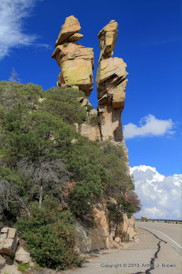
Price road heads east from northern Florence. It's pretty flat around there. There are farm fields that look like they are growing alfalfa to me. It's a pretty boring drive most of the way. Then you get to this:


The view towards the end of Price Road.

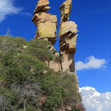
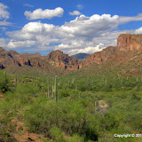
Well, I thought it was cool. There's also this:


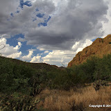
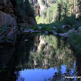
After a while, I had to turn left on Box Canyon Rd. It didn't look like I could go straight. According to maps I could have. I'll have to go check that out some time. Anyway, the drive on Box Canyon Rd is scenic.


Approaching the canyon on Box Canyon Rd.

Richard and I had been out there once a few years ago. We didn't go as far up the canyon then as I did this time. I drove until I didn't dare go any further. I didn't want to get high-centered on a rock. I guess I could have measured to see if I would have made it, but who wants to think about these things? There were also some spots where I wondered how long I would have to drive backwards once I couldn't go forward. Fortunately, there was just enough room to turn around where I had to stop.


I'm not gonna try to drive over that.

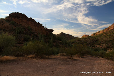
Just before I drove into the canyon, there were some dark clouds to the east. When I came out, I could see rain and it didn't seem very far away. Here I am driving in canyons and roads that follow the beds of washes. I decided it was time to get out of there. I need to go back with my ATV, though, and drive further up there.


This is 1 or 2 tenths of a mile beyond where I stopped driving. I didn't carry the GPS so it isn't geotagged correctly.


I'm glad I didn't encounter any oncoming traffic.


Approaching rain.

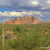
I wasn't done driving around yet, so I went to the south side of Florence and then decided that I needed to take a drive on the Florence Kelvin Highway (which is dirt most of the way). I tried going north on a couple of roads from there but they soon came to "Private Property" signs. I eventually found a road that headed northeast and looked like I would be able to follow it for a while. I was kind of looking for another road to the White Canyon Wilderness. I could see a familiar mountain from the road but the road wasn't going in quite the right direction.

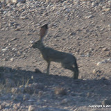
As I drove along the road I encountered another rattlesnake laying in the road. This one was dangerous. He never moved, never acknowledged my presence, never rattled. This is the kind of snake that you wouldn't be aware of until you stepped on it and it bit you.


A rattlesnake that could be more dangerous than most.

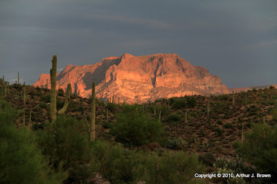
I left the snake in the road and drove on a little way further. I stopped to get some pictures of mountains in the direction of White Canyon Wilderness and then decided it was getting too dark to continue. No sense exploring the desert if I can't see where I am. By the time I got back to the snake, it had been in the same spot for 10 or 15 minutes. It still refused to move. It didn't appear to be injured, but I didn't give it a complete physical exam. Anyway, it made me change my mind about why I've been finding so many rattlers stock still in the road. They aren't hiding by freezing. They must be on the road because it's warm. They need to get warmed up before they go hunting so they will be able to make lightning fast strikes. (BTW, don't ever think that if a rattlesnake strikes at you, you can get out of the way. Humans just cannot react fast enough. Heck, kangaroo rats can't. How do you think rattlesnakes manage to eat? If you are within striking distance and they decide to bite, you will get bit. Period. The only thing that might save you is they don't like to use venom for defense. Oh, and don't think a small snake is less likely to hurt you. Small snakes are trigger happy and are more likely to inject venom.)


White Canyon Wilderness is over thataway.


Pretty clouds.

As I headed back, I decided that I was going to just enjoy the sunset and not keep stopping to take pictures. My windshield was so covered with bugs, though, I had to get out to see the sunset so I took some pictures.


I had no idea how this would turn out. It was still too bright in that direction to look at it much.

A few weeks ago I got a Delorme Earthmate PN-40. I wanted a GPS receiver with a display and that I could use to backtrack. I can also download tracks from it to use in geotagging pictures. The tracks that it produces hint that it might be better at determining position in less-than-nominal conditions than the igotU. I ran my clean-up program on the track from driving in the canyon and it discarded less than half of a percent of the datapoints. It would discard about 75% of the points from the igotU under similar conditions. So far the only complaint I have about the Delorme is that the rechargeable batteries I've tried to use in it don't last very long. I'm still experimenting with that, though.

Click below to see all of the pictures.

2010_08_08

Sunday, August 08, 2010

The drive to Roger's Trough trailhead

It was overcast and gloomy on Saturday morning and the forecast made it sound like it would be raining all day, or at least it would be threatening to rain. I decided I would go explore some roads south of Florence and try not to get stuck in mud. As I left the house, though, I saw that there were only a few puffy clouds around. Also, as I drove past the Superstition Mountains, they seem unusually crisp and vivid, as if a cold front had just gone through. As I approached the turn-off for Florence I looked at how the sky was clear in that direction and decided it would be too hot that way. Instead, I went to Hewitt Canyon road. I have been wanting to go up there again since I got new tires, to see if they were any better at climbing the steep parts of the road.


Rugged mountains and puffy clouds. I was going to be taking a lot of HDRIs.

Shortly after I got on Hewitt Canyon road, I could see some of the mountains to the northeast of Superior. Like the Supes, they looked unusually vivid. It was looking like it might be a good day to take pictures of mountains.


This part of the road seems to have been graded recently. It was smoother than it's been for a long time.


I tried composing some nice pictures, but it's hard getting in just the right spot. The right spot from which this picture should have been taken was occupied by a large palo verde.

There was very little traffic. I saw one vehicle on the way out there and two on the way back (one of which was a truck full of young guys who were tossing beer cans left and right as they went along the road).

Near the beginning of the drive I decided to hike over to a canyon I've been wanting to get a closer look at for a while. I was getting out of the truck when I noticed it was well over 100. I decided that it wouldn't be a good idea to wander off into unknown territory on such a hot day. I think it would have been a miserable hike for another reason, too. The rain we've had so far seems to have given the gnats a big boost.


Byous Butte on the right.

When I got to the really steep part of the road where I've had trouble before, it was in bad shape. It used to be a mostly smooth road surface, but now it has a couple of large dips. Kinda looks like somebody spent half an hour spinning their tires on a rainy day. I thought that would stop me for sure. It took two attempts, but I made it through that. The rest of the steep part was slow but steady. It's hard to say if the tires made any difference, though. The road used to be covered with pea-sized gravel, and it looks like that has been washed off.

It was in the low 80's at the trailhead, but it was muggy and there was no breeze, so I didn't hang around there long.


I see these really big flies on hikes sometimes. I tried putting a quarter by this one for a size reference but he took it.


The air looks a little hazy from high up.


I never noticed that stock tank before.


Looks like it's probably gotten cloudy around Florence.

On the way back down I spotted a hawk perched on the side of a water tank that must have been built many years ago. I took a lot of pictures of it. It was in a shady spot so the camera used a pretty high ISO. Every now and then I read somewhere that these days cameras take good pictures even at high ISO. Maybe the people that say that use a different definition of "good". The pictures seem very grainy to me. I guess it was good to be able to get some pictures, though.


Hawk on the side of a water tank. The tank is on a steep side of a canyon. I don't think a cow could get to it.

I also encountered another rattlesnake crossing the road. Every rattlesnake I've seen this year has been frozen in the road. I guess it's a defensive mechanism, but I bet it gets a lot of them run over. Lots of people kill snakes just because they're snakes. I took a few pictures of this one. I think I got some good shots of his tongue.


Picketpost Mountain catches the last light of the setting sun.

Click below to see all of the pictures.

2010_08_07