
Approaching Elephant Butte.
It turned out to be very easy to get to it. The road had been freshly graded all the way out there. The area seems to be an up-scale housing development. Either not many lots have been sold, or the lots are really big. The few houses that there were were very far apart.

Elephant Butte. The head is on the right.

Elephant Butte butt.
I kept going past Elephant Butte, to see how far I could get on that road. The road got much rougher past Elephant Butte. It didn't take long to get to a rough downhill spot that I didn't think I would be able to drive up if I had to come back this way, so I turned around.

The end of the road, for me.

I was thinking that this looked like a girl cactus getting ready to hug her boyfriend cactus, who was holding some flowers behind his back to surprise her. Then I started wondering if I've already been out in the heat too long.
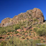
I went down another road and came to another stopping point before too long. Then I headed back to Queen Valley to get some pictures of the golf course. There aren't any pictures of Queen Valley on Panoramio. I'm going to fix that.

Queen Valley golf course.
Click below to see all of the pictures.
 |
| 2010_06_19 |


1 comment:
I see the elephant and it's cool!
Post a Comment