Monday, January 25, 2010

Halfway up the Carney Springs trail

I've been spending a lot of time at the same end of the Superstition Mountains lately. I guess I tend to do things like that, though. I was on the Carney Springs trail twice this past weekend. There are several reasons I went again yesterday. One was that I wanted to see and hear all that water again. That's an unusual experience in the desert. Another was that it was so pretty on Saturday, I wanted to see it again. The last reason is that I've been meaning to hike up to the halfway point of that trail for several months now. I decided I had better do it before I get too old, whooped out, and decrepit to do things like that. My knees ain't what they used to be, and they never were real good.


There were fewer clouds on Sunday.

I remembered that the trail kept getting steeper as it approached the halfway point, but I had forgotten just how steep. I stopped a lot on the way up to catch my breath. Being out of breath doesn't bother me as much as thinking about how difficult it will be going back down the same way. It was a little nerve wracking going down the bare rock portions with water on them.


I found another waterfall.


My destination is on top of those hoodoos.

The steep part of the hike was in the shade, and there was a cool, light breeze. Of course, I was sweating, so I was freezing by the time I got to my destination and back in the sunshine. I had thought about going further along the trail, but I just wanted to get back to my warm truck. I put on a flannel shirt but still thought it was too cold to be hiking. Gee, sounds like I'm almost too old for this already.


View from above the hoodoos.

My GPS data logger couldn't track enough satellites to navigate near the top of the hike, so pictures I took up there aren't quite correctly geotagged. When the weather warms up, I may try to get to the top of the trail. Actually, I'll probably say it's too hot. Click here to see the EveryTrail map. Click below to see all of the pictures.

2010_01_24

Saturday, January 23, 2010

A waterfall in the Superstition Mountains

We had puffy clouds today. I like puffy clouds, even if they are so thick that their bottoms are dark gray. I like them even though they force me to make HDRIs so they'll look good in my pictures.


Puffy clouds over the Superstition Mountains.

I left the house this afternoon knowing that I was going to get some pictures of them. I just didn't know where. By the time I got to the edge of the neighborhood, I was thinking I might go towards Canyon Lake, so I headed east. As I drove along Baseline road, I could see snow on the mountains out towards Superior, so I got on 60 heading east. As I drove through Gold Canyon, I kept thinking about how long it would take to drive to Superior, and so I decided to drive down Peralta road. As I drove down Peralta, I thought of several places out there that I might take a short hike. I stopped at Carney Springs Road (which is closed now). I decided to hike a short way down the Lost Goldmine trail. I stepped out of the truck and the cold wind hit me. (I'm a cold weather wimp; it was probably in the mid 50's.) I changed my mind about the hike. I turned to get back in the truck, looked up at the mountains, and stood there awestruck. They were just too beautiful. I would wear a sweatshirt and earmuffs and wool socks over my hands if I had to, but I could not resist those mountains.


Irresistible.

I watched the mountains as I walked along the remnants of the Carney Springs road. There's a place near the Carney Springs trail that I noticed many years ago where there should be a waterfall. I've seen lots of places like that in the desert, and I always wish I could be there when there is water pouring over them, but I always figured I would have to be out there in a monsoon downpour to see it. Today, I looked up at the waterfall that had always been dry before, and there was water pouring down. Not just dribbling, as I had seen in other waterfalls, but really pouring. This week's winter storms wreaked havoc all over Arizona, but it's been great for waterfalls. As I stood there taking pictures, I realized that I could even hear the waterfall.


Finally, a waterfall with water!

I was suddenly very glad that I had left the toasty comfort of the truck. I decided to hike along the Carney Springs trail for a while and see what else I could find. It's on days like this that I'm glad I have a SPOT. "They" say you should always let somebody know where you will be hiking. I didn't know where I would be hiking until I got there, but my wife and brother knew where I was within 10 minutes of when I got out of the truck.


The waterfall from closer up.

The trail soon takes you out of sight of the waterfall. I continued for a little while to see if I could spot anything else interesting. A couple of times I stopped and listened to see if I could hear any other waterfalls. That's almost impossible. I could still hear the one I could no longer see. It's a sound that is hard to locate, and sounds echo all over the canyons. Still, there seemed to be a slightly louder sound of water up the canyon I was in. I finally located it. It was water pouring over dozens of small waterfalls on its way down the center of the canyon.


I hear water up there...


... and there it is!


This is a scenic trail.

I didn't go very far up the trail. After I got into the shade of the canyon, it was too cold for me. Maybe I hadn't eaten enough at lunchtime. On the way back down, as I was passing by where I had taken a side trail to a cave a week or two ago, I noticed a large bare spot to the west of the trail. I went to check it out and found something that must have been constructed by the Carney brothers many years ago.


This is made with concrete and rocks. There's a pipe coming out of the top.


It frustrates me that I can't even capture a hint of the beauty of these mountains.

2010_01_23

Tortilla Creek in the daytime

I made it to Tortilla Flat before it got too dark after work on Friday. A guy there that has lived in the area all his life told me that he has never seen so much water in that creek. There was a lot less water than there had been the night before, though, and there was evidence it had been much higher during the night.


Tortilla Creek is almost low enough to drive across now.


There must be a shortage of signs. Maybe the "Fresh Oil" sign will stop people, though.


It isn't quite so windy today. The waterfalls are only a little sideways.

2010_01_22

Thursday, January 21, 2010

Amazing sights

Too bad it was too dark to take pictures.

We've had some wild weather lately. Lots of wind and rain. Sometimes very heavy rain. It rained almost almost all night last night. It rained off and on all day today. Around noon, the wind started blowing. It's been blowing like it does during a monsoon storm, except that it just keeps blowing. When I left work, it was raining. The wind was blowing my truck and other vehicles back and forth across the freeway. My house is about 20 miles from where I work. It stopped raining when I was about halfway home. The sky up ahead looked strange. It was fuzzy as if blurred by rain, but it was the wrong color. It wasn't gray like rain. It was tan, like ... dust!

We must have had at least a couple of inches of rain by then. Everything was saturated. It was dust, though. As I drove through it, it sprinkled now and then. The raindrops left dusty spots as they dried. Maybe it blew in from Mexico.

The freeway has some of those update-able traffic information signs. One of them said that Apache Trail was closed at Tortilla Flat. I figured it must be because Tortilla Creek was over the road. I decided to drive out there and see.

It was getting kind of dark by the time I got out to Canyon Lake. Just past the second one lane bridge, there are some cliffs to the left. I've known for a long time that there are sometimes waterfalls there because of the black streaks they leave on the rock. Before today, though, I had never seen the water.


One of the smaller waterfalls. Sorry about the poor quality. It was dark.

The waterfalls were doing strange stuff today. Remember the wind? It was blowing the water back up over the cliffs.


Waterfall being blown back up the cliff. It was a long exposure, so the spray doesn't show up much.

It was getting very dark by the time I got to Tortilla Flat. The shortest exposure I got was 4 seconds. I couldn't get the camera focused; I just set it to infinity. The creek was a roaring torrent.


Tortilla Creek. That's a lot of water.


Tortilla Flat. I was the only one there.

If anybody has any suggestions on how to focus in the dark, please let me know.

2010_01_21

Monday, January 18, 2010

Stone spire


A few weeks ago, Adam said something about a "look around" in Panoramio. I looked it up and was thinking that a stone spire at the end of Idaho Road would be a perfect subject for a look around. Since then, I've decided that Panoramio doesn't create look arounds for things that aren't buildings. Also since then, I've discovered that Picasa web albums creates street views for items that are far from any street. The only qualification seems to be that some pictures be zoomed in more than others. There was a little sunshine on Sunday, so I decided to take a bunch of pictures of the stone spire.


I took pictures of a few things besides the stone spire.

It'll be a couple of months before the street views show up. Click below to see all of the pictures. Might be kind of boring since most are of one thing. Most are also HDRIs since I didn't want the sky to be blindingly white in all of them.

2010_01_17

Sunday, January 17, 2010

A little sunshine

Over the Christmas break, I went hiking every other day, regardless of the weather. It seemed that it worked out to be cloudy on the days I was hiking and sunny on the days that I wasn't. I checked the weather forecast for this weekend and it said it was going to be cloudy on Saturday and partly sunny on Sunday. So I stayed home most of Saturday. Late in the afternoon I noticed a little sunshine. I decided I had better take advantage of that and hopped in the truck. Since I didn't have much daylight left, I headed down First Water road to the Jacob's crosscut trail, near the Superstition Mountains.


A little bit of sunshine.

There wasn't a lot of sunshine getting through the clouds, but there were some photogenic clouds. I went to the top of a small hill and took pictures until it got too dark. I took a lot of HDRIs, mostly to get the clouds to look good.


Non-HDRI. I like the way the mountains look.


HDRI. I like the way the clouds look.

Some day when I feel really ambitious I may try combining parts of pictures that I like. I think I have software that I could use to do that.


Superstition Mountains in silhouette.


Interesting clouds, lots of cholla in the foreground.

Click below for all of the pictures. No map this time.

2010_01_16

Wednesday, January 13, 2010

Something new and cool!

Well, I think it's cool. Last night I was looking at my web album for the hike I took to the top of Hackberry Mesa. I noticed a red, miniature map marker symbol the the lower right of some of the pictures. Hmm, I don't remember seeing that before. I held the pointer over it and it said, "View in Google Maps Street View". That seemed a little odd for a picture in which no streets were visible and that was taken over 1.6 miles from the nearest street. I thought Google had made a mistake. Then I clicked on it. A new window opened showing the picture, and it had several gray trapezoids in it. I clicked on one of the gray trapezoids and it opened a picture I had taken zoomed in on that area. Cool! You can go back and forth between pictures. You can view it all full screen.

It only seems to work with geotagged pictures. I'm going to take some pictures this weekend that will intentionally exploit this new feature. The trouble is, I'll have to wait a few weeks to see the result. No web albums newer than the end of November seem to have had this feature enabled. Go to the Hackberry Mesa album to check it out for yourself. I hope this feature is added to Picasa some day.

This is like the "look around" feature on Panoramio (which doesn't seem to be applied to landscape photos) or Photosynth from Microsoft.

Monday, January 11, 2010

Near the Carney Springs trail

Saturday was a beautiful, sunny day. By the time I started to leave for a hike, though, it was after 3. I decided it was too late and instead charged the motorcycle battery. Sunday, it was overcast. Dangit.

So then I thought that I should take the ATV out to Bulldog Canyon and drive down some roads I hadn't been on in a few years. I hooked it up to the charger on Sunday morning. It was charged after lunch and I tried to start it. And tried and tried. Then I gave up.

I loaded my camera and backpack into the truck and headed out, wondering where I was going. I wanted to go someplace different. I couldn't think of someplace completely different that was nearby, so I drove down Peralta road thinking that I would stop somewhere along there or maybe even hike on a trail at the end of the road. I wound up stopping where the road that used to go out to the Carney Springs trail was. The road is closed now (long, sad story) and I haven't been out that direction since it closed. I figured I could walk where the road used to go and see how long of a walk it is. It turned out to not be as bad as I was afraid it would be. I got to the Carney Springs trail and started along it, still thinking that I wanted to see something different.


This is where the road used to be. It's been dug up, and there have even been a few cacti stuck in the dirt (that's all it takes to get them growing).

The Carney Springs trail gets to a spot where it looks like there may have been a concrete water trough at one time. There are only a few pieces visible in the dirt now. I was looking around in that area when I noticed a side trail heading east. Cool, something new! Of course, I followed it. It went a few yards and became hard to follow. Then after a few more yards it crossed a small wash. Then it all but disappeared. A fair amount of people had to have gone this way, though, so I was determined to follow it whether I could see it or not. So I started going uphill, because that's a direction I often like to go, and downhill didn't look interesting. Somebody that had been on the "trail" recently couldn't be bothered to step over plants in the path, so I was able to follow a trail of smashed brittlebush, smashed fairy dusters, and displaced rocks. The smasher didn't step on any cholla, though.


Somebody left a trail marker that turned out to be a Planet Hollywood windbreaker from Paris. I kept it.

Since I was in an area that was new to me and because it would be easy to lose the trail, I was stopping frequently to look around. On one of those stops I spotted a cave. I thought that must be the trail's destination, and it did go there.


A cave.


On the inside looking out. Gee, writing that took me back to the mid-60's. The Animals. Wasn't a big hit in the colonies.

After looking around in the cave (not much to see), I went up on the rocks on top of it. The view was much better up there. From up there I thought I could see some mine tailings. I knew there was a mine up there somewhere, but I didn't know where. I thought I had found it. Stomper had gone in that direction, too, so maybe I was on to something.


One of the views from above the cave. Find the truck!

As it turned out, what looked like tailings from a distance was actually solid rock. I walked across to the other side. The "trail" continued beyond there but the slope it was on got too steep for me. I didn't want to descend doing cartwheels through cacti. I headed back down the slow way.

My GPS data logger did pretty good until I got up on the side of the mountains. I'm convinced that it's the terrain in which I hike that's causing all the problems. Well, that's not gonna change (I hope).

The GPS track looked good on the @trip map, but when I uploaded it to EveryTrail, it looked like I flew back and forth across a canyon at 85 mph. Wow, I wish I could really do that! The @trip software must filter out stuff like that. EveryTrail allows you to edit the track, so I moved a couple of track points over to the correct side of the canyon. There's still some screwy stuff in the data. I'm doing this for fun, though, so I'm done worrying about it.

Click here for the EveryTrail map and below for all of the pictures.

2010_01_10

Tuesday, January 05, 2010

To the top... of something

Sunday was my last chance to go for a hike before heading back to work after the Christmas break. It was a beautiful day so I had to go do a little more exploring. My cold had me feeling a little drained, though, so I wasn't planning to do a lot of climbing. I was just going to wander around in the area I had been over the past few days.


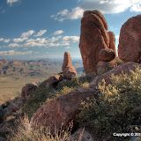
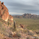
This picture is from a previous hike. I was looking in this area and thinking I should go explore over there some time. That's where I headed today.

I decided to make a halfhearted attempt to get on top of a ridge I was looking at a couple of days before. Amazingly, my semi-random decisions about which way to go resulted in getting to the top fairly easily. The view was great from up there.


I was on a north-facing slope, so there were natural terraces.


Terrace building plants.


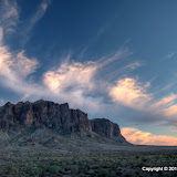
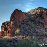
A view from the top. I was so high up, I could see the curvature of the Earth. Just kidding.

My i-gotU GPS data logger didn't log much data on this hike. My SPOT didn't seem to perform too well in the same places, so maybe the mountains didn't permit visibility of enough GPS satellites. My program discarded 90% of the track points. A lot of pictures could not be correctly geotagged by the @trip software and I wound up re-positioning them using Picasa. I had to kind of guess, but at least I knew which side of a mountain I was on.


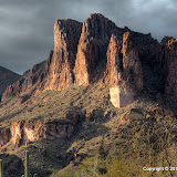
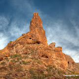
I was on top of that. Unfortunately, there is nothing for scale so you have no idea how big it is.

As you can see in the previous picture, there are cliffs on 2 or 3 sides when you get to the top. From up there, they seem like very tall cliffs. I wanted to peek over the edge, but I just could not make myself get closer than about 6 feet from the edge. Since I couldn't stand on the edge, I wanted to lay down and slither up to the edge and peek over and get some pictures, but there weren't any spots at the edge with patches of bare rock that were big enough. A patch of bare rock big enough to lay on is necessary. Have I ever mentioned that it seems that most plants in the desert have thorns? Those thorns fall off the plants all the time. They are all over the ground. You don't spit into the wind, you don't tug on Superman's cape, and you don't allow your body (or backpack) to come into contact with the desert ground. The two exceptions are 1) if the ground is bare rock that is obviously free of thorns (and cracks that could be hiding scorpions, but that's another subject) and 2) loss of consciousness.


This makes nice wallpaper.

On an unrelated subject, it has been a little over 13 months since I bought my SPOT satellite messenger. I've been pleased with it. Actually, I've been more pleased that I haven't had to use the 911 button on it. When I first got it I was kind of bummed to see that it requires the use of those expensive lithium batteries, because they're expensive and I'm cheap. My first use of the SPOT was a trip to Texas. I had the SPOT on in tracking mode (transmitting to a communication satellite 3 times every 10 minutes) for about 40 hours that week. I was sure that would drain the (expensive) batteries, but it didn't. I've used the spot on every hike I've taken since then, so it's been on and in tracking mode for from 3 to 10+ hours a week, ever since I bought it. I carry spare batteries in my backpack, but I haven't had to replace them yet.


My SPOT in its usual position on my backpack.

The SPOT has a single belt clip thingy for attachment to whatever (sorry about all the technical terms). I clip it on a loop at the top of my backpack. The first time that I lifted my back pack out of the truck after a getting back from a hike, the SPOT came unclipped and went clattering across the garage floor. It's very rugged, though, and that didn't bother it at all. It did bother me, and not just because my fancy new electronic gizmo that cost a lot more than the expensive batteries it contained was clattering across the garage floor. If it can come unclipped so easily in the garage, I could lose it in the desert. In the picture, you will see that I've added a lanyard that clips to another location on the backpack (in case the strap the SPOT is clipped to fails; I'm a belt and suspenders kind of guy). There have been several occasions when I've found the SPOT swinging by the lanyard. It's a darn good thing I put that on there.

This is a perfect illustration of one of those "that's good / that's bad" things they used to do on Laff In or Hee Haw or something years ago. It seemed bad when I dropped my SPOT, but it was actually good because it kept me from losing it later. That also applies to my La Barge Canyon misadventure. I got careless, I made some bad decisions, and I put myself in a sticky situation. Fortunately, I just got a little wet from sitting in the lake (hey, I got a new wallet that is much smaller and doesn't hurt my hip!). I'm now careful to observe all of my hiking-by-yourself-in-the-desert rules so I don't find myself in a similar or worse situation again. My backpack sure is heavy from all the water I carry, though.

Yes, the La Barge Canyon misadventure was a good thing, though it was not much fun at the time. Some hikers are not so fortunate. There was an article in the paper this weekend about one of those less fortunate hikers. Though Bryce Gillies was just 20 years old, he had a lot more hiking training than me and had youth on his side. He wasn't a brash young kid doing stupid things, though. He did made a series of bad decisions, and there was no way out for him.

Click here for the EveryTrail map and below for all of the pictures.

BC_2010_01_03

Saturday, January 02, 2010

Last attempt for this area

I decided to make one more attempt to get to the top of the Goldfield Mountains in this one area. For once the sun was shining. It was in the upper 60s and there was just a light breeze. I packed food, lots of water, extra clothes, and got an early start. My only concern was that I have a cold. If it had been a work day, I would have had to stay home from work. The company is concerned about swine flu. They always tell people to stay home when they're sick, but they've really been emphasizing that this year. My cold seems to be mild, but I would be the only person at work with a cold if I went in. I would have felt guilty going for a hike instead of going to work. Didn't have to worry about that, though. I had planned to head home as soon as I felt like the cold was making me feel drained, but except for a few sneezes there wasn't any problem.


Ah, it's nice to have sunshine for a hike.

The sneezes were kind of cool. My family tells me I sneeze too loud, but I'm trying to keep it down. When I'm hiking, though, I don't hold back. I heard some cool echos from the mountains and in the canyons.


I'm going to try going up over there.

It turns out that I couldn't get very far where I had planned to climb. When I'm on a steep slope hundreds of feet above the desert floor, I kind of loose my nerve. That's probably a good thing, though. The view was nice from where I was. I found a flat rock and sat down to have a snack and enjoy the view. I probably would have stayed there a long time, but a honey bee kept bumping me. Then another one joined him, and they started bumping more. I decided to leave before more showed up or somebody got trigger happy. I don't want to be trying to outrun killer bees on a steep slope.


Too risky to cross this, and I might not be able to go far beyond it.

On the way downhill, I saw something large and shiny off to my left. Naturally, I went to investigate. It was just a rock, but while I was there I noticed a canyon that also needed investigation.


There's a canyon back there. I need to check it out.

I saw no sign of people in that canyon, except for one balloon and that doesn't count. I'm sure somebody has been back there, but people don't go there very often. I was hoping to find some undiscovered native American ruins or something, but of course I didn't. The canyon quickly got steep and I couldn't follow it very far.


Looks like it turns right and gets narrow.


This turned out to be less impressive than the Wind Cave on Pass Mountain.


Looking up the canyon. It gets pretty steep.


I sometimes find water in the desert, but I haven't found anything I'd like to drink.

I couldn't go far beyond the pool of water. I meandered back to the truck along a different route. I saw footprints (other than mine) and horse hoof prints when I got closer to the road. Whoever was back there didn't seem to go far, though.

Click here to see the map, or below to see all of the pictures.

BC_2010_01_01