
As you can see, I have it on the strap to my Rebel right now. I think I'll move it as soon as I think of a better place to carry it. It's a little inconvenient right there. It's small enough that I could put it just about anywhere. When I look at it, I think about the first GPS receiver I ever saw back in '78. That one was about 3 feet long, 2 feet wide, 1.5 feet high, weighed over 150 pounds, and the cooling fans screamed like banshees.
I went for a quick hike out at the end of Meridian road today to try out the logger. I was taking pictures just to take pictures. I didn't do any editing, and I put all of them on the web album, so don't be shocked. The purpose is to show how nifty the logger is. I could have refined the position of some of the pictures. Normal GPS error shows some of them having been taken a few feet off the trail when I know I was on the trail. Still, the accuracy will be much better than my guesswork in the low resolution areas.
The logger comes with software that can use the GPS track to geotag pictures. This time I used Microsoft Pro Photo Tools because it will allow you to shift you pictures with respect to the track if you don't have your camera time set correctly. I must have had the camera clock dead on, though; didn't have to adjust the time at all.
The logger software will also generate some kind of travel log with pictures to put on the web. I'll have to experiment with that. Sounds like it might be nifty. I noticed today, though, that you can view Picasa web album pictures on a map and "play" the pictures in sequence, so that you can see the pictures and where they were taken on a reasonably sized map. You can try it out with this album.
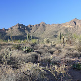 |
| Meridian_2008_10_27 |


3 comments:
aww how cute I gotU
Yeah, it's made in Taiwan, and they made no effort to make it look or sound macho for their Yankee customers.
Hey guys,
ckeck out locr.com!
Just a nice geotagging community!!
Post a Comment