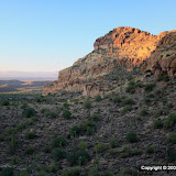
I sat at the base of a cliff taking pictures for several minutes. During that time, my GPS data logger seems to have wandered around by itself. Suzanne said that maybe one of the hawks took it for a ride. The trip statistics say that my average speed was 8 kph and my maximum speed was 5 kph. I don't know how that's possible. Maybe because I was moving so much when I wasn't moving. Also, my minimum altitude was 91 meters below sea level. Blub, blub. Maybe being next to a cliff in a canyon blocked most of the GPS satellite signals.
I used to have the data logger set up to log my position every 6 seconds. I bumped it up to 10 seconds and that seemed to double how long the battery should last. I was thinking that might be because it doesn't write to EEPROM as often, but maybe it's because it shuts down the receiver for longer logging intervals and doesn't get as good of a fix when it comes back on. Anyway, I set it back to 6 seconds and we'll see how it does on my next adventure.
 |
| BC_2008_11_16 |


No comments:
Post a Comment